Avalanche PRO
The Atlas AvalanchePRO is a pioneering unmanned aerial vehicle (UAV) system specifically designed to assist first responders in locating individuals buried under snow following avalanches. By integrating a leading avalanche sensor into the award-winning AtlasPRO platform, the AvalanchePRO enables rescue teams to scan extensive areas safely and efficiently, significantly reducing the time and cost compared to traditional manned aircraft methods. This innovative approach enhances the speed and safety of search and rescue operations, providing a critical tool in life-threatening situations.

The Atlas AvalanchePRO represents a significant advancement in search and rescue technology, offering a safer, more efficient, and cost-effective solution for avalanche response efforts.

IP 57 Water Resistant

Up to 40m Detection Range

ON-BOARD Encryption

Radiometric
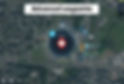
Multiple Beacon Locations

Encryption Frequency- hooping MESH

Max. flight time with payload
32 min
Ascent speed
5 m/s
Max. service ceiling
3000 m
Wind resistance
15.5 m/s (56 km/h)
Descent speed
3.5 m/s
Max. speed up to
56 km/h
MESH Technology
AtlasMESH is a networking system that allows a single operator to operate numerous drones at the same time. Deploy, operate, and use many UAVs using a single control station without the need for extra hardware.

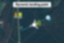
BVLOS Missions
Signal is relayed by a secondary UAV that flies behind challenging barriers where the signal is typically lost.

UAV Hot-Swap Functionality
In circumstances when continuous monitoring is required, replace a depleted UAV with a fully charged one without interrupting the video stream.

Share Mission Data
On a mesh network, share critical mission information such as coordinates or a video feed with other devices.
Advanced Missions
The AtlasSTATION is a touchscreen tablet, which can be used to control AtlasPRO from anywhere within range. Seamlessly create missions, set routes and operate a drone(s) at a distance. AtlasSTATION's interface also provides for data management, video streaming, and integration with third-party systems.

Payload Options